

GACP Projects
GACP Progress Report, FY 2000
PI: Cora E. Randall
Address:
University of Colorado, Laboratory for Atmospheric and Space Physics, Boulder, CO 80309.
email: randall@lasp.colorado.edu
tel: (303) 492-8208
fax: (303) 492-6946
CoIs: Mike Callan, Frank Eparvier, Dave Rusch, and R. Todd Clancy
Title: Solar Mesosphere Explorer Measurements of El Chichón Aerosols
Proposal Abstract: We were funded to "resurrect" data from the Solar Mesosphere Explorer (SME) in order to provide the climate community with information regarding stratospheric aerosol forcing after the eruption of the El Chichón volcano in 1982. The database provided by this proposal will enable climate modelers to subtract stratospheric aerosol effects from column measurements in order to define the tropospheric aerosol contribution after the El Chichón eruption. The goal is to provide the climate community with the optical depth of aerosols in the visible, near infrared and thermal infrared spectral regions. Specifically, SME radiance data from the 0.44, 1.27, 1.87, and 6.8 µm channels will be used. We proposed to improve on previously published retrieval techniques in order to extract and publish extinction and size distribution information over more extended spatial and temporal regimes than previously possible.
Objectives: To understand and predict global climate change, it is necessary to accurately assess the radiative forcing caused by atmospheric aerosols. Of the natural radiative forcings, injections of aerosols into the stratosphere by volcanic eruptions are the most significant with regard to the global radiation balance. The overall purpose of this program is to extend the satellite measurements of global stratospheric aerosol profiles back in time to the eruption of El Chichón in 1982, using SME data. SME made global measurements of aerosols from several months prior to the eruption of El Chichón through 1986. The SME radiance data are being inverted to calculate aerosol extinction profiles at 0.44, 1.27, 1.87 and 6.8 µm. These profiles and the total vertical optical depths derived from them will be provided to the climate community for input to global models.
Approach: The approach is to modify existing codes [Eparvier et al., 1994] to develop new algorithms for calculating aerosol extinction at the four SME aerosol wavelengths. Previously, aerosol extinction profiles and vertical optical depths at 6.8 µm were calculated from the SME data, but with limited temporal and spatial resolution and coverage. Proposed improvements to the new inversion codes include reducing the amount of radiance profile binning, to improve the temporal and spatial resolution of the derived extinction profiles. The intent is also to use a water vapor climatology for subtraction of the water vapor component in the 6.8 µm channel, to allow calculations of extinction beyond late 1984 (the limit of previous work). In previous work [Eparvier et al., 1994], aerosol extinction profiles were not calculated at wavelengths of 0.44, 1.27 and 1.87 µm. This is because the goal of that work was to produce size distribution parameters, and this was possible without completing a full inversion of the data. The approach here is to invert the slant path radiance profiles to obtain profiles of the phase-modulated extinction coefficients. Assumptions for size distribution parameters (and thus the scattering phase function) based on the work of Eparvier et al. will then be used to calculate the aerosol extinction profiles and vertical optical depths in all channels. Other improvements to the algorithms include using NCEP data to model the Rayleigh contribution to the near-IR radiance profiles, rather than climatological temperatures.
Second Year Progress Report
A. Summary of First Year Progress
During the first year of the proposed work, the 6.8-µm retrieval algorithms were improved, and all data were inverted with the new algorithms to generate extinction profiles. The most significant improvements were inversions on an event-by-event basis (instead of calculating only weekly, and thus zonally averaged, profiles), and a significantly more accurate water vapor subtraction scheme [Callan et al., 1999]. These profiles are available to other team members. Also during the first year, algorithms were developed for calculating extinction profiles at 1.27 and 1.87 µm, and algorithms for inverting the lower wavelength data were brought online (but require modifications before implementation).
B. Second Year Progress
At the end of the first year and beginning of the second year, the 1.27 and 1.87 µm radiance data were evaluated to determine if the signal to noise ratio was high enough for the new algorithms to be applied reliably on an event-by-event basis. During this evaluation, however, we discovered errors in the SME radiance data. While not an original goal of the proposed work, we made the decision that we should fix these radiance profiles before inverting them to obtain the 1.27 and 1.87 µm extinction coefficients. This has led to an unexpected and unavoidable delay in calculating the extinction coefficients at these wavelengths. Although this problem was unanticipated, it is perhaps not surprising that such delays would be encountered when working with data obtained more than 15 years ago.
Calculation of Merged Radiance Profiles
The problem in the radiance profiles originated in the altitude registration of the profiles of raw counts vs. time. Briefly, an inappropriate algorithm resulted in substantial oscillations in the radiance profiles near the top of the aerosol layer, which would have prevented us from obtaining accurate results in the inversion to extinctions. More specifically, in order to improve the signal-to-noise ratio in the original near-IR SME radiance data, six successive "raw" spin radiance profiles were combined to make one "merged" radiance profile. For example, Figure 1 shows the individual 1.27 and 1.87 µm raw profiles of counts vs. bin number for an arbitrary set of observations on July 24, 1982. In order to combine such profiles, it is necessary to register them on a common altitude grid. This is accomplished in several steps. First, the SME ephemeris is used to convert bin numbers to altitudes for each radiance spin profile. Next, each radiance spin profile is interpolated to a standard altitude grid. Finally, radiances from all six spins are averaged at each of the altitudes on the standard grid.
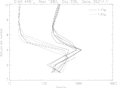
Figure 1. SME "raw" profiles of counts vs. bin number for a set of profiles acquired on 24 July 1982 at 1.27 and 1.87 µm.
The original interpolation to the standard altitude grid employed 4-point LaGrange interpolation. This algorithm works well for radiances that vary slowly with altitude, which was the case for the original altitude region of interest (e.g., when the SME data were used for mesospheric ozone retrievals). Radiances due to aerosols, however, often change rapidly over small changes in altitude. Thus, at the lower altitudes relevant for aerosol retrievals, using 4-point LaGrange (cubic) interpolation often results in large errors in the interpolated radiances. Examples of the types of errors introduced are shown in Figure 2. For illustrative purposes, the interpolation was performed in altitude bin space (so the individual profiles are not yet registered in altitude), but the results have the same character as they would have had they been interpolated to the standard, high-resolution altitude grid. Note the extreme variations in the radiance profiles between altitude bins 4 and 7.
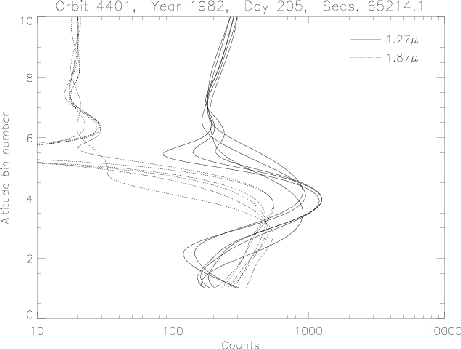
Figure 2. Data shown in Figure 1, interpolated to a fine altitude grid with an interpolation scheme similar to that used in the originally archived SME radiance profiles — note the oscillations in the profiles between altitude bins 4 and 7.
The types of errors illustrated in the above figure can be greatly reduced by doing 4-point LaGrange interpolation on the natural logarithms of the radiance values, converting the interpolated values back to radiances by computing their exponents. Errors can be reduced still further by replacing the 4-point LaGrange interpolation with interpolation using splines under tension. An example of the same data interpolated in this manner is given in Figure 3.
At the time this report is being written, approximately half of the second year funding has been used. In the latter part of this year, the "fix" described above will be applied to all radiance profiles at both 1.27 and 1.87 µm, and new merged radiance profiles will be calculated. These profiles will then be inverted to calculate extinction profiles.
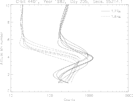
Figure 3. Data shown in Figure 1, interpolated to a fine altitude grid with splines under tension applied to the natural logarithms of the radiance values.
SME Data Archival
We consider the modification of the merged radiance profiles to be a significant accomplishment of this GACP project, even though it was not part of our original objectives. The SME data are very valuable — they represent the only near-global measurements of both aerosol, ozone, and NO2 profiles during the El Chichón time period. In today's environment, such measurements can only be repeated at great expense to the national government. Too often, "old" data sets are neglected, and the data thus become obsolete. Primarily because of the work being done under this GACP program, the SME data will be properly archived and available for future research. Fixing the errors in the merged radiance profiles required access to SME ephemeris data that were held on old 9-track tapes which were difficult to read. These tapes are all between 11 and 19 years old, and a few of them required considerable effort to read due to deterioration of the magnetic media. That ephemeris data has now been brought online successfully, and will be archived on new media, as will the new merged radiance profiles.
In addition, we were able to apply for and obtain internal (CU/LASP) funds to properly archive the rest of the SME data set (i.e., the data not directly related to our funded GACP aerosol project). Obtaining these funds was only possible because we were able to leverage off of the work we had accomplished and experience we had gained working with the SME data archive under the GACP program. Thus, the progress we have made in this GACP program will be beneficial to a wider audience than originally envisioned.
Finally, the SME UV data (265 nm — not used in this GACP project) are being used for studies of polar mesospheric clouds (PMCs) and their relevance to global change. The errors that we found in the algorithm for merging the near-IR radiance profiles are also present in the UV data, and can significantly affect retrieved PMC profiles; using non-GACP funds, these profiles can now be corrected.
Validation
Once the near-IR extinction profiles are calculated, they will be compared to measurements of aerosol extinction at 1 µm made by the Stratosphere Aerosol Measurement (SAM) II and Stratospheric Aerosol and Gas Experiment (SAGE) II instruments.
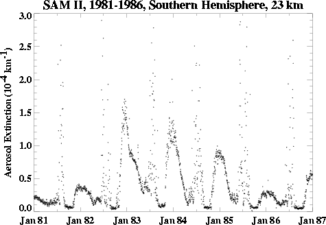
Figure 4. SAM II measurements of aerosol extinction at 1 µm for an altitude of 23 km. All measurements were acquired in the polar region (see Figure 5 for the latitudinal coverage of SAM II). The measurements from 1982 through 1986 will be compared to the 1.27-µm aerosol extinction measurements from SME.
In anticipation of this, we have obtained all of the relevant SAM II and SAGE II correlative data. As an example, Figure 4 shows the time series of SAM II data in the southern hemisphere (latitudes poleward of 53°S) at 23 km. Note that at these high latitudes, the effects of El Chichón are not evident until the end of 1982. The variable, but very high, extinctions during the winter months are due to polar stratospheric clouds.
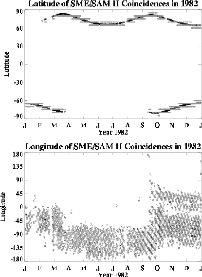
Figure 5. SAM II (o) and SME (+, gray) measurement latitudes (top) and longitudes (bottom) for coincident events in 1982.
During the second year of this grant we have also isolated correlative events which are coincident with the SME measurements. For instance, there are more than 2000 coincidences between SAM II and SME in 1982 alone, where we have defined a coincident event as occurring within ±24 hours in time, ±5 degrees in latitude, and ±15 degrees in longitude. Plots of the SAM II/SME coincidence data set latitudes and longitudes for 1982 are shown in Figure 5. The SME near-IR aerosol measurements span 1982 through November of 1986. SAM II measurements are available for this entire period; SAGE II measurements began in late 1984, and are still being made. One advantage of the SAGE II measurements is that they cover a latitude range from 80°S to 80°N in approximately one month.
C. References
Eparvier, F.G., D.W. Rusch, R.T. Clancy, and G.E. Thomas, Solar Mesosphere Explorer satellite measurements of El Chichón aerosols. 2: Aerosol mass and size parameters, J. Geophys. Res. 99, 20,533-20,544, 1994.
Callan, M.T., C.E. Randall, D.W. Rusch and F.G. Eparvier, Aerosol Extinctions Derived from Solar Mesosphere Explorer Satellite Data, GACP science team meeting, NY, NY, September, 1999.
GACP Bibliography
Callan, M.T., C.E. Randall, D.W. Rusch and F.G. Eparvier, Aerosol Extinctions Derived from Solar Mesosphere Explorer Satellite Data, GACP science team meeting, NY, NY, September, 1999.
Third Year Statement of Work
During the third year, we will first complete inversions of the new radiance profiles to obtain 1.27 and 1.87-µm extinction profiles. These will then be compared to the correlative SAM II and SAGE II extinction profiles to assess the quality of the SME inversions. Any significant deviations will be explored further to determine if revisions to the current inversion algorithms are warranted. Sensitivity tests will be run on the 1.27 and 1.87-µm retrievals to evaluate systematic errors due to the size distribution assumptions employed. Also, we will explore using NCEP temperature profiles rather than climatological profiles in the near-IR inversions. If necessary, the inversion codes will be revised and re-applied. The final work will be published in the refereed literature, and the extinction profiles and total optical depths at 1.27, 1.87 and 6.8 µm will be made available in a public database.
Note: PDF documents require the free Adobe Reader or compatible viewing software to be viewed.
